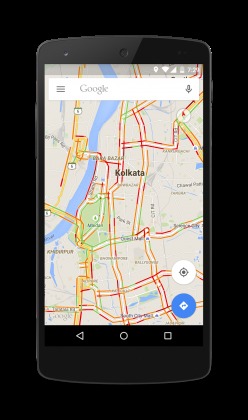
One of the worst things about living in the city is getting stuck in traffic jams, especially if you’re on your way to a crucial appointment. While India may not be considered the worst when it comes to traffic congestion, some cities in the country may very well be in the top 100 or something. That is why Google Maps in India has now finally started adding traffic information in 12 cities, helping drivers see real-time the conditions on the roads including all national highways and expressways.
The 12 cities included are Kolkata, Coimbatore, Lucknow, Surat, Thiruvananthapuram, Indore, Ludhiana, Visakhapatnam, Nagpur, Kochi, Madurai, Bhopal. But the inclusion of the highways and expressways are for everyone who’s driving through the country, The traffic layer onto the map will be color coded for easier navigation. Green means there are no traffic delays, orange refers to a medium amount of traffic, while red indicates heavy congestion. Having this information on your screen will help you plan which route to take or to re-estimate your time of arrival for those who are expecting you.

Using Google Maps’ Navigation mode will use this real-tine traffic information to be able to give you alternative routes, should there be any other options available. It will also recalibrate your arrival time so that expectations will also be recalibrated. This is also a useful feature not just for residents of the cities, but even for visitors who will be unfamiliar with the usual traffic conditions in the area.
The traffic layer for Google Maps should be rolling out for users in India. It will be available for both mobile and desktop versions.
SOURCE: Google India


“While India may not be considered the worst when it comes to traffic congestion,..”… yeah…. that’s because the people who study india’s traffic congestion never turned in their reports because THEY’RE STILL STUCK IN TRAFFIC!!!!