Google Maps continues to become more than just that app that you open when you’re lost in an unfamiliar place. It has become a staple whether you’re driving to a destination, commuting to get there, or even going on a ride-sharing service. Possible upcoming features may become important for the latter two as we may be seeing new options for first-mile transit combinations, another addition to bike options, more accurate ride fare information, and a slight tweak to the user interface.
Reverse engineering expert and tipster Jane Manchun Wong shared several tweets about Google Maps’ possible upcoming useful features. First off, if you’re taking a ride-sharing app like Uber, you can send Google Maps route information to them directly so as to have more accurate fares based on that. Uber seems to be the only one listed in the enabled feature but Lyft and other ride-sharing services may also be included soon.
Google Maps is working on an option to “Get more accurate fares” from ride services by sharing route information to them pic.twitter.com/BGh0eCtjoI
— Jane Manchun Wong (@wongmjane) June 20, 2020
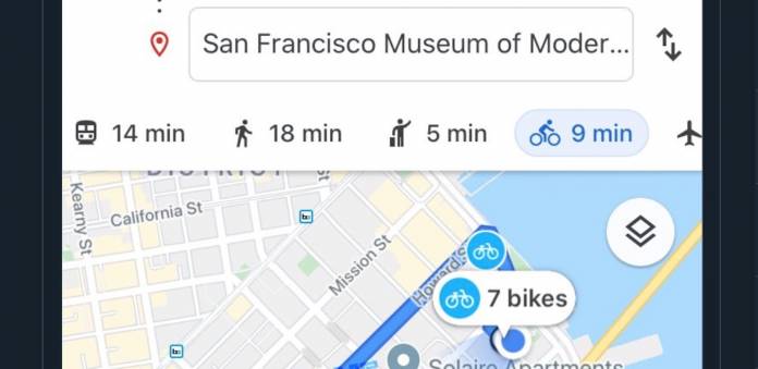
Bike-sharing service “Bay Wheels” from San Francisco may get deeper integrators within Maps. The screenshot Jane shared indicates it will be included as an option in the directions, next to walking and ride-sharing. This may mean that other bike-sharing services will be added, depending on your city and the availability of such services. This may be similar to how the ride-sharing option also includes multiple services.
Google Maps is working on deeper integrations for bike-sharing service “Bay Wheels”, providing it as an option for directions pic.twitter.com/guzgQ2cneq
— Jane Manchun Wong (@wongmjane) June 20, 2020
Google seems to be working on “Connect to Public Transit” options where you can choose what your first-mile transpiration will be. Options on the screenshot Wong shared include cars, bicycles, auto-rickshaw, ride service and motorcycles. The + transit means you’ll be connecting to a form of public transport after a while. This will be useful for those who have to go through different modes when going to work or wherever.
Google Maps is working on route options with “Connections to Public Transit”, such as:
– Car + transit
– Bicycle + transit
– Auto rickshaw
– Ride service
– Motorcycle + transit pic.twitter.com/hLlCZJG7Av— Jane Manchun Wong (@wongmjane) June 20, 2020
Lastly, Maps may be working on a new place card design. The photos look like they are part of the card already. Currently, the photos are above or behind the card but the screenshot shows integration with the card. Let’s see which of these things make it to the final Google Maps update eventually.
Google Maps is working on a new place card design where the Photos became part of the card pic.twitter.com/LyS8wU9oIh
— Jane Manchun Wong (@wongmjane) June 20, 2020


